Scientific research work Digital information model of management of development of the territory of Nizhnevartovsk | Muratov Artem Evgenievich
When creating the CIM URT, a large array of source data was analyzed.
A unified data bank on the current state of the city's territory has been formed (a digital platform for creating a CIM URT), which includes: — data on housing, — generalized data on people living in the city, — on social, transport, and communal infrastructure facilities, — data from the Unified State Register of Real Estate, etc.
There are 200,000+ spatial objects with attribute content in total.
A digital twin of the territory of Nizhnevartovsk has been prepared — a BIM 3D model of the current state of the city's territory at the LOD 200 level of detail, and orthophotoplanes have been prepared based on aerial photographs of the territory.
Conceptual strategic solutions for the development of the city's territory have been developed: concepts for the spatial development of the Nizhnevartovsk agglomeration and the city of Nizhnevartovsk, and a master plan for public spaces. Regulatory legal documents regulating urban planning activities (local standards of urban planning design) have been prepared and approved.
Based on the information from the database on the current state of the territory, changes have been prepared to all types of urban planning documentation to ensure continuity of decisions: the general plan of the city, planning and surveying projects, a project for surveying public areas (street and road network), rules of land use and development. Taking into account the identified needs, the list and deadline for the implementation of all planned infrastructure facilities necessary for the development of the city (programs for the integrated development of social, transport and communal infrastructures) have been determined. The parameters establishing the requirements for building and the quality of the urban environment (rules for the improvement of the city territory, the general scheme of landscaping of the city) have been approved.
An analysis of the business processes of the Nizhnevartovsk City Administration was performed and proposals for their automation were prepared in the form of a methodology for creating a CIM URT.
Automation solutions have been developed and implemented based on approved scenarios, including training for specialists from the Nizhnevartovsk Administration.
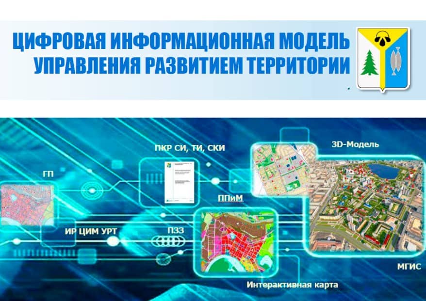
CIM URT includes the following systems:
- Municipal geographic information system.
- Information panels "Workplace of the supervisor" on the platform.
- Interactive map.
- The CIM URT portal is available on the Internet.
- 3D portal of Nizhnevartovsk available on the Internet.
CIM URT makes it possible to effectively make management decisions taking into account the opinions of residents, the balance of needs and provision of necessary facilities based on a mathematically sound approach and the principle of rational location, as well as reduce the time required to provide services by automating processes and actively interacting with the population, administration, business and resource supply organizations.
- The foundation has been created for the digital transformation of the city and the transition to the concept of a "data-driven city."
- Increasing the attractiveness and competitiveness of the city for investors, developers, entrepreneurs, and residents.
- Obtaining reliable information about the city's territory and decisions made on its development by all interested parties on the 3D portal of the city using the digital twin of the city's territory — a realistic 3D model of the existing state of the city's territory, ensuring the publicity and accessibility of urban planning solutions.
- Participation of city residents in surveys and votes on proposed design solutions.
- The possibility of publishing 3D models of buildings and landscaping facilities, embedding objects in a 3D model of the city for public discussion and approval of project proposals.
- Ensuring the search for a site for investors, developers, entrepreneurs, and residents of the city, taking into account approved urban planning decisions, and increasing the transparency and attractiveness of the city's territory for investment and development using the CIM portal.
- Implementation of interactive information analytical panels "Supervisor's workplace" to obtain and visualize reliable, up-to-date information about the current state and planned development of the city's territories.